
IN OUR EARLY days of boating, we cruised the Gulf Islands on holiday weekends, but summer vacations were a chance to head north and explore new anchorages. The challenge became choosing the best route to take up and down the Strait of Georgia.
1. COPELAND ISLANDS
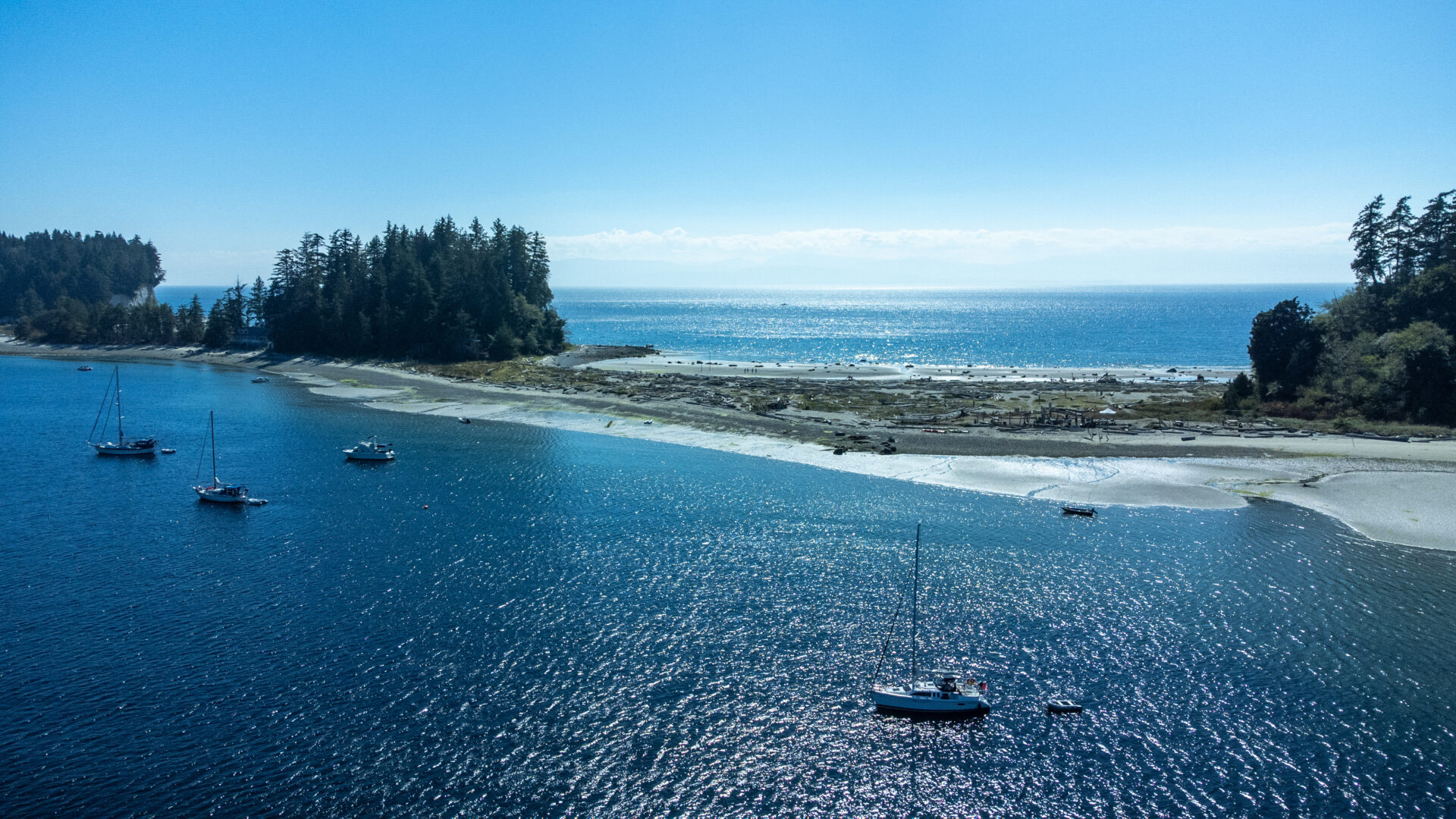
Boating trips are at the mercy of the weather and this is especially true when sailing the open waters of the Strait of Georgia—where we learned the hard way to allow a day’s grace in case of bad weather. One summer, we were nearing the end of our two-week vacation when we found an ideal fair-weather anchorage in the Copeland Islands. It lies in the passage running between the two southernmost islands, where a handful of boats can anchor. Most favour the south side but we picked the north side, choosing to anchor in a nook wedged between grassy bluffs. From atop their wooded crests, we could gaze upon our boat lying at anchor with a stern line to shore.
The next day dawned bright and sunny, so we decided to stay another night and enjoy the anchorage. After all, we still had three days of vacation left and could make it back to our marina in Ladner in two days from the Copeland Islands. These islands lie at the north end of the Sunshine Coast, just around the corner from Desolation Sound, and are a marine park popular with boaters and kayakers. Interesting rock formations line the foreshore and there’s pleasant hiking inland through thin stands of spruce and arbutus. From our nook it was an easy row across the cove to its west entrance, where tiers of pink granite descend into the sea. Feeling our barefooted way down these smooth steps – warmed by the afternoon sun—we eased into the water for a swim.
That evening, as we lounged in the cockpit enjoying the fine weather, we
noticed a row of mare’s tails spreading across the sky, but it wasn’t until the next morning, while preparing to leave, that we listened to the weather forecast: a southeasterly gale was expected in 24 hours. We were soon joining other boats hurrying south in search of a sheltered anchorage.
2. JEDEDIAH ISLAND
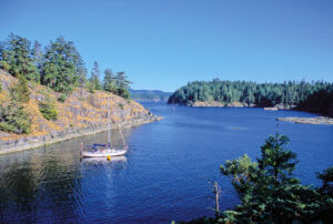
Deep Bay at the north end of Jedediah Island provides good shelter but it was already filled with boats when we arrived, so we proceeded down Bull Passage until we came to a small, empty cove opposite Boho Bay. A reef sits in the middle of its entrance but, after a careful look at the chart, we slowly motored into the cove and set both anchors to lie parallel with the northern shore—a rocky bluff dotted with conifers.
The next morning we headed into Bull Passage to test the waters, for both of us were due back at work the following day. As we punched into a headwind, our Scottish terrier (who didn’t care about jobs) began to tremble inside his flotation jacket. We ignored him until we reached open water at the south entrance to Bull Passage. Here, an 80-mile fetch exposes mariners to the full brunt of southeasterly gales. Our compass told us the wind was coming from the exact direction we wanted to go. The pounding seas told us it would not be an enjoyable ride. So, we did what our dog was silently willing us to do—we turned the boat around and flew back up the channel to our hurricane hole.
That afternoon, Bill climbed to the top of the bluff to make a couple of calls on his cell phone. Then he went for a quick spin in the dinghy and returned with reports of boats packed into Deep Bay and others huddled against a log boom outside the bay in the lee of the island. The next day, we tacked our way south in moderating conditions, phoning our workplaces from the middle of the strait to make sure they had received our messages. “Anne!” exclaimed the receptionist, “Are you still trapped on that island?”

We’ve returned often to Jedediah Island, which became a marine park in 1995 after its owners, Al and Mary Palmer, offered it to the provincial government at a fraction of market value. Their wish was to see the island preserved as a park. A major fundraising drive, which included a large donation from the estate of Dan Culver, provided enough funds for the government to purchase the island.
Since becoming a marine park, Jedediah Island has become increasingly popular. On one of our subsequent visits we arrived at Sunset Cove—the anchorage that had sheltered us years earlier—only to find another sailboat anchored there. We decided there was room enough for us to squeeze in and turn their one-boat anchorage into a two-boat anchorage. If looks could kill, we would have been struck down as we slowly motored past their boat to the head of the cove, where we dropped anchor and tied a line ashore. We spent the afternoon hiking the island’s sheep trails and left the next morning, leaving the other boat to its solitude.
Henry Hughes, a gentleman farmer from Ireland, owned Jedediah Island in the 1920s and ‘30s. After depleting his financial resources and losing all of his hired help, he lived alone on the island with his faithful dog Caesar. Suspecting trespassers of poaching his sheep, the reclusive Hughes once greeted a tugboat captain named Jim Anderson with the pointed barrel of a gun and an order to get off his land. Anderson, who regularly anchored his tug in Deep Bay, eventually befriended the bearded, bookish Hughes by bringing him back issues of city newspapers, then inviting Hughes and Caesar to dine on his vessel, where the dog enjoyed a special place set for him next to his owner.
Al and Mary Palmer were the last private owners of Jedediah Island and were known for their friendliness and hospitality toward visitors to their island. Their old homestead and fruit orchard is at Home Bay, where a hilltop meadow overlooks the water, as does a plaque commemorating Dan Culver. A local yachtsman and world-famous mountain climber who fell to his death in 1993 at the age of 41 after summiting K2, Culver’s wishes were that his estate be used to preserve a piece of coastal wilderness. His family chose Jedediah Island, and we are all the richer for this act of generosity.
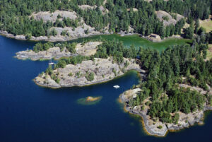
Jedediah Island contains a network of sheep trails, one of which leads from Home Bay to the broad beach lying at the head of Codfish Bay—a narrow cove near the south end of the island. The cove is sheltered from northwest winds and partially protected from moderate southeast wind and swell off the Strait of Georgia by a cluster of small islands near its entrance. The setting is starkly beautiful, with a cliff-sided islet forming part of the cove’s northeast shoreline. A lone deer once stood atop this cliff and gazed down at our anchored boat, but we’ve more often sighted feral goats and sheep roaming the island. Their presence is being monitored because they graze on native flora and impact the island’s ecosystem.
The island’s highest point, dubbed Mount Gibraltar, stands at the south end of the island and is reached by a trail that ascends 150 metres above sea level, winding past ferns, salal and dwarf conifers. The summit provides sweeping views of nearby islands and Jedediah’s rugged shoreline.
3. THORMANBY ISLANDS
In contrast to the rockiness of Jedediah Island are several nearby islands with sandy beaches. Lying a short distance to the east are the Thormanby Islands, where a sweep of sandy white beach stretches along the west side of Buccaneer Bay. Sheltered anchorage can be found in the Surrey Islets on the bay’s east side, from which it’s a short dinghy ride to the beach.
4. HORNBY ISLAND
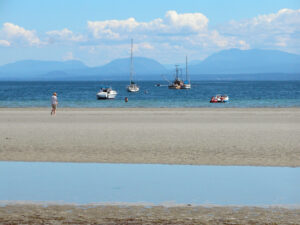
Another stunning beach lies west of Jedediah Island, at the head of Tribune Bay on Hornby Island. In settled weather, this is a splendid summertime anchorage. The bay provides good shelter from the prevailing summer northwesterlies and although it is completely open to the south, the holding ground is good in sand and mud. Keel boats anchor a fair distance from the head of the bay, where the gradually shelving bottom becomes a wide expanse of sandy beach at low water.
Overlooking the entrance to Tribune Bay is beautiful Helliwell Park—a gift from an accountant named John Helliwell who donated this land to the province in 1964 because he felt “it was too beautiful to not share.” We have walked to this park after landing our dinghy along the bay’s eastern shoreline, where the sandstone bedrock has been eroded into honeycomb hollows. A path at the head of the bay winds through a picnic area to the road leading to Helliwell Park. Upon reaching the park, a sign-posted trail at the entrance takes you through a forest of Douglas fir which opens onto a sweeping meadow of golden grass shimmering in the sea breeze. The panoramic view from this bluff takes in the Strait of Georgia and the mountains of Vancouver Island stretching across the western horizon. The sea cliffs below consist of sandstone and conglomerate rock, which attract great numbers of nesting cormorants and gulls.
5. HERNANDO ISLAND
Yet another beautiful beach lies at the northern tip of Hernando Island, extending in both directions from Spilsbury Point. On various visits we have dropped anchor either west of the point or east of it in Stag Bay. This is a fair-weather anchorage, open to the north, but the sandy holding ground is good. We treat this as a lunch stop and like to spend a few hours lazing on the beach of soft white sand, enjoying the expansive views down the strait. To the northeast lies the entrance to Desolation Sound.
Anne Vipond and William Kelly are the authors of Best Anchorages of the Inside Passage, a guidebook detailing anchorages and passes along the south and central coast of British Columbia.